As part of my midseason review of my boat and its systems, I realized my electronics and charting abilities aren't current. Where did the time go? Some of these changes in equipment reflect movement within the industry. While I suppose that might be a good thing, it certainly throws a monkey wrench into the status quo.
Last fall, Garmin acquired Navionics, which some saw as an acknowledgement that the electronics company knew Navionics charts were superior to its own proprietary BlueChart G2 charts. And soon after Garmin discontinued its own BlueChart Mobile app. I didn't realize that. And the forums and social media were abuzz that Garmin's BlueChart cartography was history when they acquired Navionics. Well, that is another fabulous example of misinformation overload on the Internet, simply trying to find out what is really going on at Garmin. Good luck with that! I wasted time searching the Web for definitive information, but so much of it is from years ago, outdated or misinformed. I contacted Garmin Support directly, and was assured the company will continue to support BlueChart charts. The current BlueChart U.S. version for my GPSMAP 1040xs is v2018.52.
When I asked about the Navionics acquisition and its impact on BlueChart, I was told, "Navionics will likely get incorporated into our charts, but we haven't had any concrete info on what/how/when the integration will look like."
My old iPad has the BlueChart Mobile app with BlueChart charts from 2013, and I noticed my Garmin 1040xs chartplotter still has the original preloaded charts from 2014. They work just fine, but given it is four years later, I should buy the latest version of these charts for my plotter.
Unfortunately, I bought a newer, faster iPad but can no longer download the mobile app. I can still use the old iPad if I want to, however.
This got me wondering about the navigation apps I use regularly and others not so much. My best experience has always been with the Navionics HD app for the U.S. and Canada. While I liked the Garmin BlueChart app, I kept going back to the Navionics app. And the Navionics app keeps getting better. Auto routing is very helpful, for instance, and charts are updated frequently.
On the old iPad I also have the Nobeltec TZ app, but using raster charts is outdated, especially with crowd-sourced data becoming normal in modern vector charts. Perhaps I can download C-Map charts for the Nobeltec app but I haven’t had much reason to try and figure that out.
I off and on tried iNavX, but frankly, it never made any sense to me. Some rave about iNavX, which I do not understand at all. Hearing my negative comments, a friend sent me a link to the user manual for the iNavX app, and I laughed when I saw how many pages it was. Nothing should require that level of documentation! Nothing intuitive there, and it reminds me of the early days with the Cap’n. That was a lifetime ago, when Jay Phillips developed Nobeltec out of a little storefront in a strip mall in Issaquah, outside of Seattle.
I guess it will eventually become clear where this Navionics/Garmin relationship is going. I would love to be able to plan trips on my iPad using the Navionics app, then transfer them to the Garmin plotter. (The BlueChart Mobile app was never able to do that. Intentionally.)
I am no electronics expert, but it sure seems we boat owners have been conditioned by the industry to spend huge amounts of money on marine electronics, many of which quickly lose their value as new features pop up. They still work, but new functions in newer models lure us into upgrading equipment. Analog to digital, then HD, then UHD, 4K, 6K, and so on. This leads me to think that sticking with basic electronics and using smartphones and tablets is a safer way to keep from throwing away tens of thousands of dollars as long as the functionality and safety factors are there and updated. I have owned three Garmin Nuvi automotive products in my life, but Google Maps on the iPhone is better, faster, and stays current automatically. The Nuvi doesn't stand a chance in this competition. The same is true with my car nav systems, compared to smartphones. Why spend $150 a year to update the car's map CD when my phone app does so for free and offers better road condition reporting?
On my last couple of boats, in addition to dedicated marine electronics, I had a high-end, daylight readable Argonaut laptop with Coastal Explorer, but that makes no sense in my current situation, and frankly, the idea of a PC seems difficult to justify today.
(I’m writing this on my favorite computer of all time, a small Lenovo 100S Chromebook. It is super portable, cost me $149, the battery lasts forever, and it has the highly rated keyboard designed for writers and journalists, a direct descendant of the legendary IBM ThinkPad. I can’t imagine spending $2,000-$3,000+ ever again for a laptop in this era of Cloud Computing. Doing so just to be able to navigate on a boat is not a path I’d walk down today.)
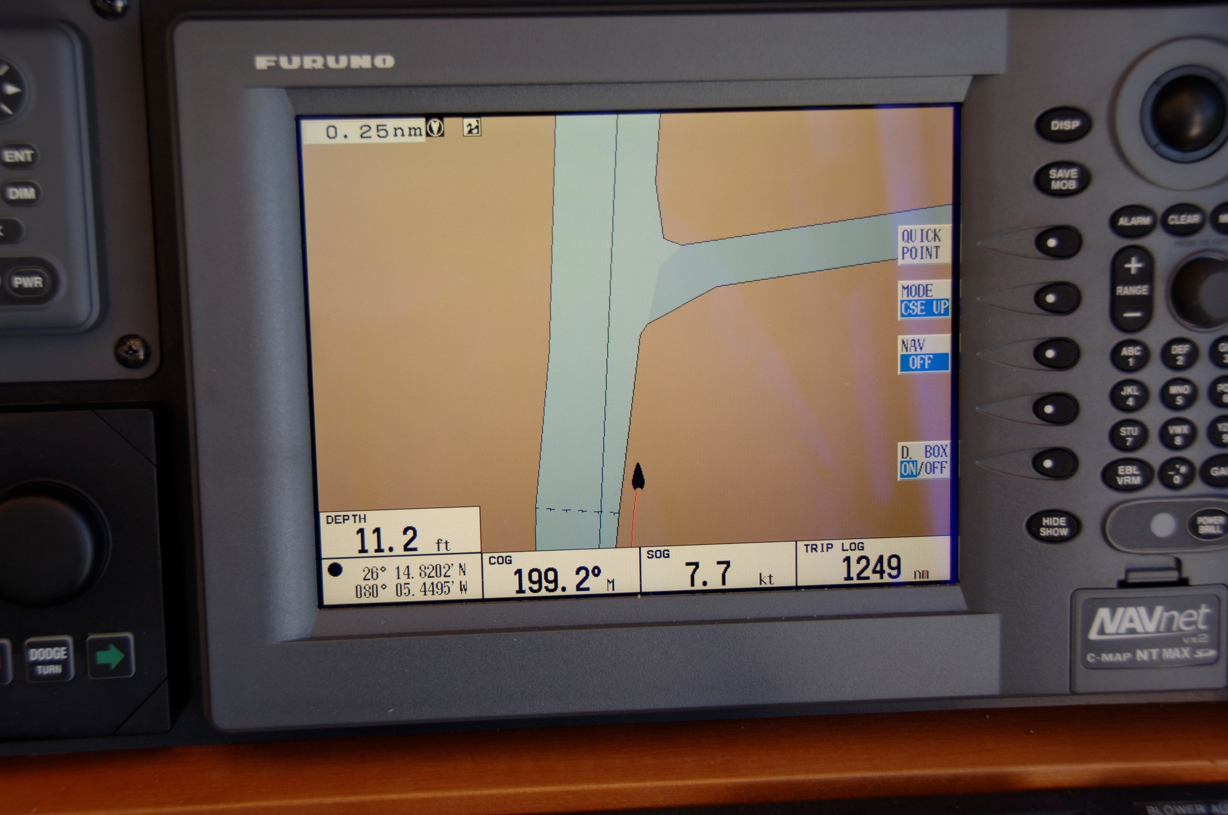
I include this screen shot of my Furuno plotter on Growler while running down the ICW near Miami. It is a great example of why one should NEVER rely on a single navigation device or app. Is the chart wrong or the GPS?
The world continues to change at a rapid pace, and with crowdsourcing functions like Active Captain, and whatever else is around the next corner, I know there will be something new some smart person is only now beginning to imagine.
The next Jay Phillips?


